Event JSON
{
"id": "323590f915ad3437ac7a4e19a78bd1bcc1b4b950a1a8d98240f156a2a27dba09",
"pubkey": "17c45717ec7b55fc3a7e2adecc5b657c865753019b9d26d266aa875b0ed3edba",
"created_at": 1745735064,
"kind": 1,
"tags": [
[
"proxy",
"https://bne.social/@didoesdigital/114408493155767856",
"web"
],
[
"imeta",
"url https://assets.bne.social/media_attachments/files/114/408/425/084/240/411/original/daee22f935950f7d.png",
"m image/png"
],
[
"t",
"queensland"
],
[
"t",
"waves"
],
[
"t",
"30daychartchallenge"
],
[
"imeta",
"url https://assets.bne.social/media_attachments/files/114/408/483/547/578/591/original/c14a3449cfef2e75.png",
"m image/png"
],
[
"proxy",
"https://bne.social/users/didoesdigital/statuses/114408493155767856",
"activitypub"
],
[
"L",
"pink.momostr"
],
[
"l",
"pink.momostr.activitypub:https://bne.social/users/didoesdigital/statuses/114408493155767856",
"pink.momostr"
],
[
"-"
]
],
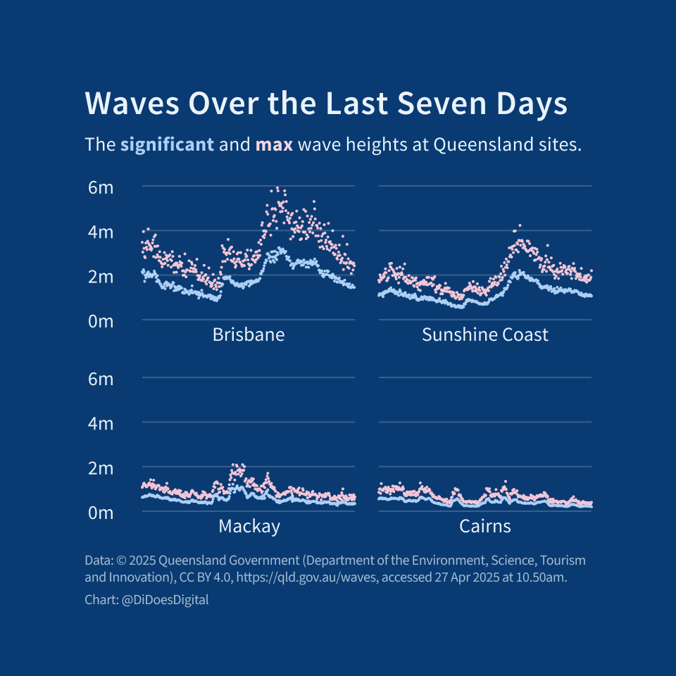
"content": "I'm delighted to learn that the Queensland government measures the height and direction of waves along the coast.\n\nThey use it for things like planning construction, investigating erosion, emergency services during cyclone season, global wave monitoring and so on.\n\nYou can use it to plan surfing, fishing, and the like!\n\nhttps://www.qld.gov.au/waves\n\n#30DayChartChallenge #Queensland #waves\nhttps://assets.bne.social/media_attachments/files/114/408/425/084/240/411/original/daee22f935950f7d.png\nhttps://assets.bne.social/media_attachments/files/114/408/483/547/578/591/original/c14a3449cfef2e75.png\n",
"sig": "a7a6ed6d3f104f20db22a1f449484d1a5aeb7471f3eb233765c0d824f2e10048cc0c1c0c9de66f57296df0c74ace15f7ed38c7e7dffbbfc91a7c4f8b0210dd76"
}